


Geology in Action at The Gap
/Geological Survey WA team member Lauren Burley (red Jacket) shares research techniques with participants in Geology in Action field session at the Gap, Albany
The rugged Southern Ocean coast of Albany's beautiful Torndirrup Peninsula offered cold gusty southerlies and a welcome shower to more than 25 keen adventurers for the Geology in Action event at The Gap in October.
"After that first shower, the sun came out and dried up the site, but the group was very enthusiastic and keen to learn whatever the weather", said Dr Catherine Spaggiari of the Geological Survey of Western Australian and Great Southern Science Council
Catherine teamed with Dr Sandra (Sandi) Occhipinti of the University of Western Australia to encourage community members to experience the field work and meet scientists involved in a southwest western Australian geological survey field trip.
The event began with introductions of the field survey team (see below), an explanation of the Geological Survey of Western Australia (GSWA) within the Department of Mines and Petroleum (DMP), research at UWA (Sandi), and the visiting geologists from the Department of Geology in the Ministry of Mineral Resources from Greenland.
The large group chat included...
Explanations about what the research team is doing and why
Geology is not only useful for mineral exploration but is fundamental to other research such as landscape evolution, ecology and biology, environmental science, as well as land use planning and tourism
Note that the data collected and published by GSWA are freely available online and provide an extensive public resource www.dmp.wa.gov.au/Geological-Survey/Geological-Survey-262.aspx
Explanation about the link between the geology in the Albany area to the better understood eastern part of the geological belt where GSWA has been working recently (east of Norseman), and to the rifted portion in Antarctica. Research in the Albany region, and indeed throughout the Great Southern region, is required to understand those links, and to be able to define the similarities and differences. The Albany region can inform us about the other regions, and vice versa.
Geological mapping is very much modernised, but still requires direct observations of the rocks.
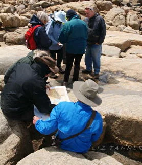
Participants in the Geology in Action field day learn about mapping features with Geological Survey of WA researcher Dr Catherine Spaggiari (centre, green jacket)
The group then split into two pods of participants to explore the site and talk with scientists, with Catherine’s pod chatting initially nearest the car park area, and Sandi's pod climbing further up the features for a broad view.
Catherine's pod
Catherine showed the group basic principles of mineral and primary rock identification, and how to understand what has happened to the rocks after they initially formed, by looking at mineral and textural details (metamorphism and deformation).
The group discussed questions about where the rocks formed, how deep in the crust, and differences between extrusive (volcanic) and intrusive (e.g. granites) processes of rock formation.
Questions were asked about how rocks formed at several kilometres depth get to the surface and the group discussed processes such as buoyancy of magmatic rocks, transfer along large faults, and the the link between uplift and erosion.
There were also questions about the shapes of the boulders and outcrops, and weathering processes, and whether these were typical at this site.
Catherine also fielded questions about how geologists and collaborators approach mapping, how they decide what to do and where to go. Catherine suggested that much of this depends on analysing available imagery and data first, then working out the issues that need to be resolved.
The group looked at the cross-cutting relationships of the complex rocks at The Gap, and how to observe the youngest to oldest rocks and their features.
Participants also viewed site geophysical imagery on the tablet field computer, where they could see the rocks through the vegetation and water.
Sandi’s pod
Sandi's group was also interested in the imagery on the tablet field computer and wanted to know what aeromagnetic, Landsat TM, and radiometric imagery represented.
Aeromagnetic images show the relative magnetic intensity of a 3D volume of crust that penetrates several kilometres below the surface.
Radiometric data is a measure of the abundances of potassium (K), thorium (Th), and uranium (U), of the top 30 centimetres of rock and soil.
The group discussed how rocks deform, and noted evidence of this in the rocks at The Gap. They also discussed how the rocks observed were formed at great depth under elevated pressure and temperature and how they got to the surface where they are now exposed.
Sandi discussed questions regarding students being able to access company data and company drillcores for their projects, and how the geological community work together to educate up and coming geologists. Sandi noted that, in general, this works very well and most companies will help with student projects as it also benefits them. The WA Department of Mines and Petroleum also release company reports and data for public access.
Thanks to Dr Catherine Spaggiari of Great Southern Science Council and Geological Survey of Western Australia for arranging this unique opportunity for regional community members to talk with scientists in the field, and to the entire team for sharing their interest, inspiration and expertise during this Science In Our Community event.
Dr Catherine Spaggiari - Geological Survey of Western Australia
Lauren Burley - Geological Survey of Western Australia
Dr Sandra Occinpinti - School of Earth and Environment, UWA
Dr Vaclav Metelka - School of Earth and Environment, UWA
Ashley Uran - PhD student, School of Earth and Environment, UWA
Kristian Grube - Ministry of Mineral Resources, Greenland
Arent Heilmann - Ministry of Mineral Resources, Greenland
Department of Parks and Wildlife provided permits and advice to the survey team and GSSC. South Coast NRM and the Western Australian Museum Albany and Great Southern Weekender helped with promotion, and Liz Tanner donated some images from the day for participants.
Great Southern Science Council encourages adventurers to contact the organisers or on-site team for more information on anything discussed on the day.
Please complete our quick online feedback survey to help GSSC plan more and better events.
Contact the team via projectofficer@greatsouthernsciencecouncil.org.au
Discover more online:
www.dmp.wa.gov.au/Geological-Survey/Geological-Survey-262.aspx